
Using Uinta and Geode for RTK Correction
Among the various methods you could employ to enhance the precision and accuracy of the position data that Uinta records, you could use real-time kinematic positioning (RTK). In very simple terms, RTK makes use of a base station with a fixed location. The base station receives signal from available satellites and shares what it has received (packaged in NTRIP format). Uinta works with your Geode to compare the signal that it received with the one that the base station received. The comparison of both signals can help establish a location more accurately. When you make use of the RTK capability of Uinta with Geode, the position data recorded will be more accurate.
RTK networks are available worldwide. They may be free or paid, privately owned, or run by a government. To locate a network near you, please consult our database: Find an RTK Network.
When you use Uinta with Geode as your GNSS receiver, you can enter your correction service information directly through Uinta. You will need the information about the RTK network that you will use and a connected Geode.
With your Geode connected,
Got outdoors to an open area.
From Uinta's main menu, select Connect & Manage GPS > Location Settings. (Several paths in Uinta lead to the Location Settings box. Use the one you are most familiar with.)
Tap Network RTK Settings.
Select your RTK provider. If you haven't entered the details of your RKT provider, see Add a network RTK provider.
Tap

Enter the following information about your NTRIP service.
Note: Much of this information, such as the caster's address, will be provided to you by your RTK service provider.
A name for the profile (Profile Name)
The address of your NTRIP caster (NTRIP Caster)
The port being used
Your username
Your password
By default, Uinta will send your position to your NTRIP provider. You can deselect, if desired.
Select Secure connection if your NTRIP provider requires it.
Select the mount point.
Tap
 to download possible mount points.
Tap the Mount Point field to select a previously downloaded mount point.
Specify the Coordinate Reference System (CRS) used by your RTK provider. Select a CRS from the drop-down list. By default, Uinta uses 4326:WGS84.
Tap Coordinate Reference System.
Tap the desired coordinate reference system, or Select Other to locate and load another.
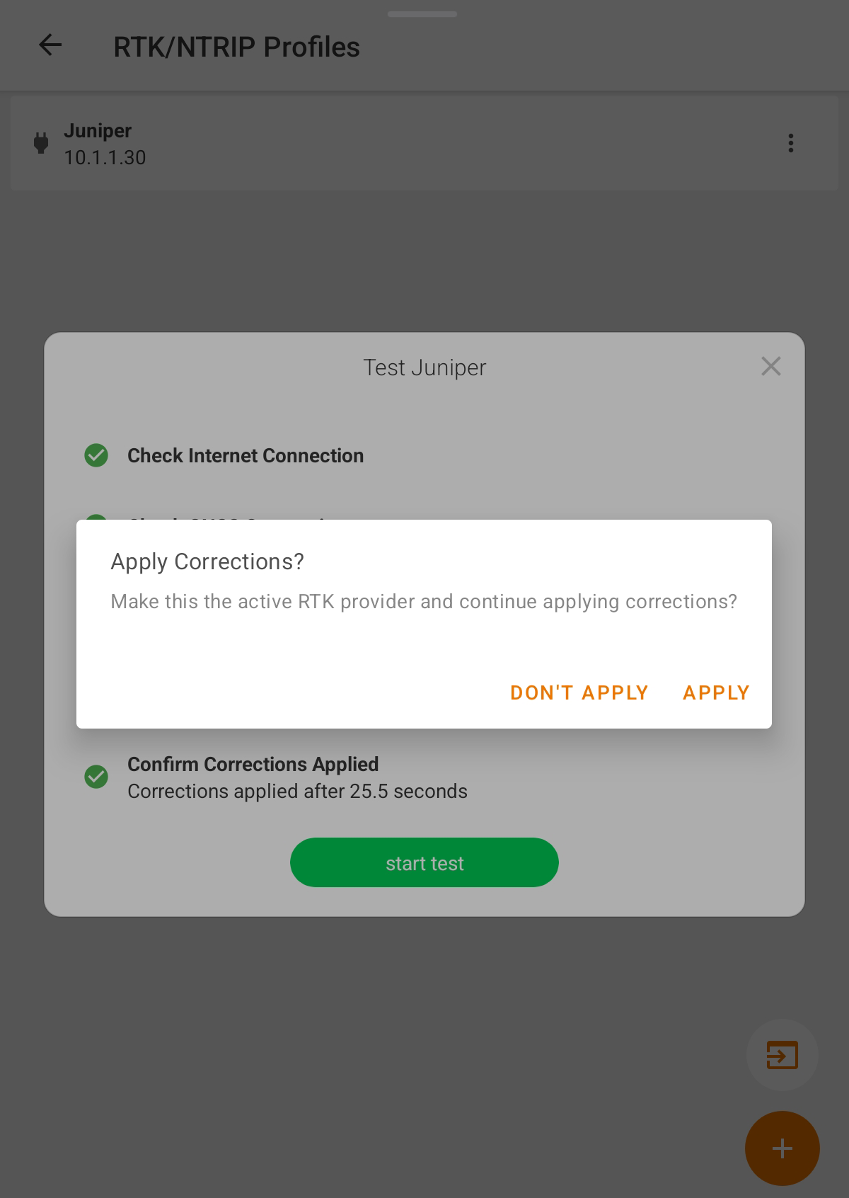
Tap Test to check that Uinta can access NTRIP provider and apply the settings. When the test is finished, you choose to apply the corrections or not.
Tap GNSS Receiver Settings.
<< Tap .
Note: To ensure a successful connection to NTRIP, confirm that you have a satellite fix before tapping Start NTRIP.<<Go to an outdoor area...
Tap Connection Source.
Set the Correction Source.
Auto—Uinta and Geode determine your best available correction source. When NTRIP data is received, the RTK correction will be used. If it is not received SBAS or ATLAS corrections will be used if available.
NTRIP—Uinta and Geode use NTRIP data to provide RTK corrections. If NTRIP data is not available, no correction will be made.
Tap Save.
Tap .
Tap NTRIP Settings.
Tap to create an NTRIP Profile. If you already have a profile, you can edit it.
Once you have created an NTRIP profile, you can select it and begin your corrections from the GNSS Configuration box. If you have a Juniper RTK subscription, you will not need to create an RTK Profile. To begin corrections from the the GNSS Configuration box,
Tap to connect to your NTRIP provider and begin receiving corrections.
Note: To ensure a successful connection to NTRIP, confirm that you have a satellite fix before tapping Start NTRIP.
Check that Fix Quality: RTK displays in the Select GPS Location Source box. You may have to wait a bit for the fix type to update.
Close GNSS Configuration.
Suggested Links
GNSS (GPS) Spatial Reference Systems
Uinta – Coordinate Reference Systems