
Importing USGS Topography Maps & Aerial Images as Reference Layers
The U.S. Geological Survey (USGS) has accurate, free-to-use topographical maps and aerial imagery that can be imported into Uinta as reference layers. These layers offer additional context by overlaying on the base map. You can save reference layers to the cloud for anyone with project access and download them to your local device for offline use in the field.
Note: For more information on reference layers, see "Use Reference Layers" in the Uinta User Manual.
Step 1: Download a USGS topographical map and aerial imagery.
Go to the USGS Topographical Maps at ngmdb.usgs.gov/topoview/.
Select Get Maps.
Go to the desired location by doing one of the following:
In Search by location, enter a location and press Enter.
Zoom to the desired area on the map.
Identify the map you would like to use.
Note: USGS maps are stored in chronological order.Select the file type. Choose KMZ or GeoTiff for import into Uinta.
After the image folder downloads to your device, locate the folder and extract the files.
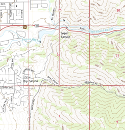
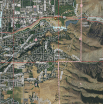
Each folder contains a topographical map and an aerial image:
The topographical map displays contour lines and elevation data along with labeled roads, cities, and natural features.
The aerial image shows labeled roads, cities, and natural features.
Step 2: Import the file as a reference layer in Uinta. (See "Import a Reference Layer" in the Uinta User Manual.)
Reviewed & Approved: TB, 11Aug2025