Geode Features
The Geode is a real-time, precision GNSS receiver. This means the Geode provides sub-meter, sub-foot, decimeter, and centimeter accuracy options which include SBAS Corrections, RTK, Atlas, and Galileo High Accuracy Service. This is the cutting edge of geospatial technology. Historically, this level of precision and accuracy was only available via post-processing software or expensive survey-grade equipment.
Accuracy and Precision
It is important to note that in the context of GPS accuracy and precision are related but not the same thing.
Accuracy refers to the radius of the circle of unknown around a true point. The smaller the radius, the higher the accuracy. The exact range of the Geode’s accuracy depends on the corrections used. This means the Geode can plot a position to within a sub-meter (or better) radius of the true point.
Precision refers to repeatability or how frequently a receiver can plot a point inside the circle of accuracy and whether that circle is centered over the true point.
Over time, any stationary GPS receiver will plot multiple positions for a given point. This happens because of errors caused by variables in the satellites, the surrounding physical environment, and the ionosphere. Modern geospatial technology has made huge progress in correcting for those errors, but a receiver’s real-time accuracy is dependent on its ability to process those corrections. The points plotted by the stationary receiver eventually form a scatter plot. Precision is the percentage of points on the scatter plot that fall within the circle of accuracy.
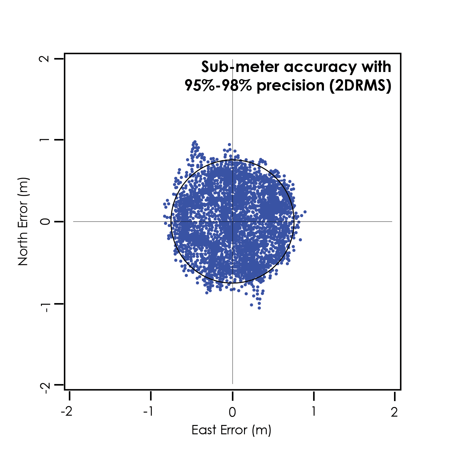
For the Geode in ideal conditions, 95–98% of the points on a scatter plot will fall within a sub-meter radius of the true point.
GPS manufacturers report their accuracy in different ways. They use different statistical descriptions of probability. A GPS receiver may be sub-meter. That is, it may be able to plot points within a meter radius of the true point. However, those points may only fall within that meter radius, 50–60% of the time. The accuracy for those receivers is sub-meter, but the precision is only 50–60%.
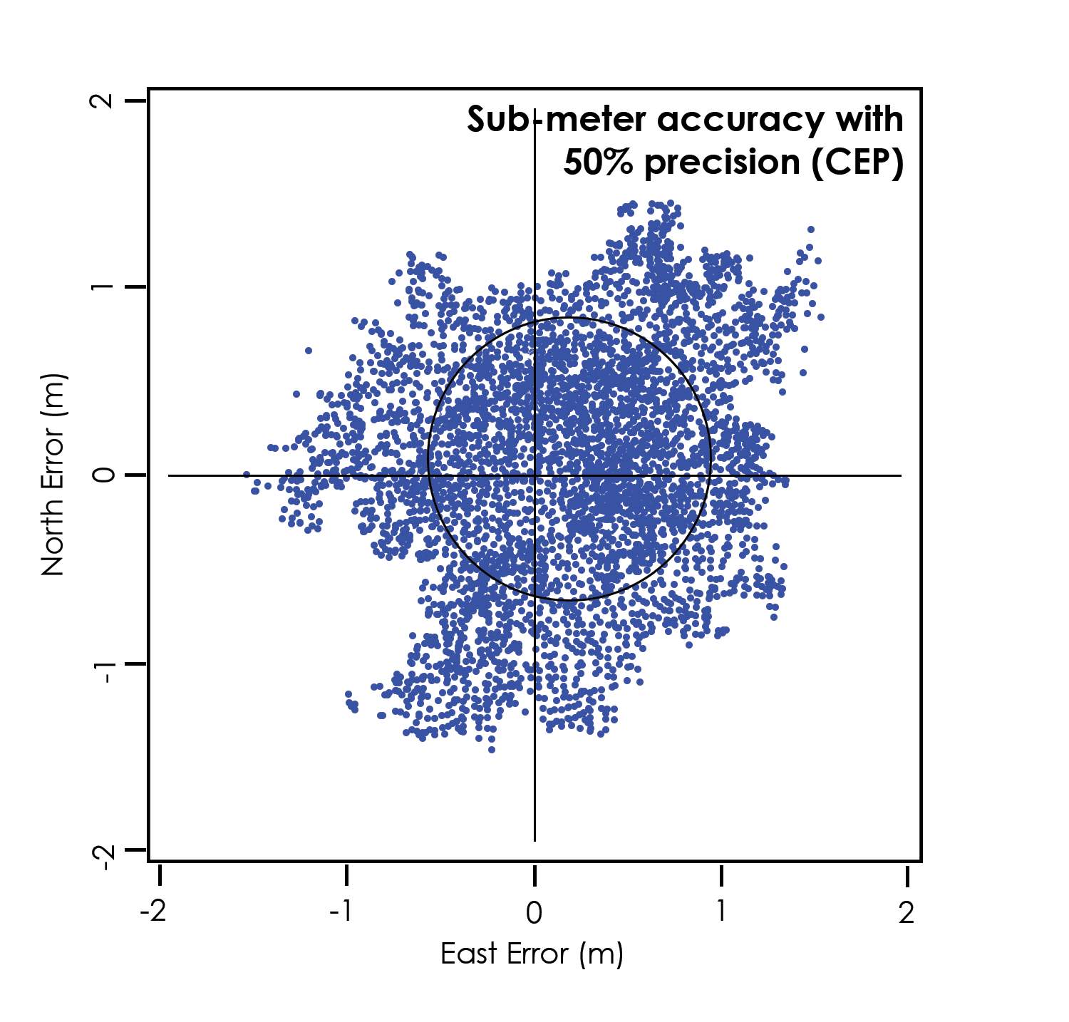
These claims largely depend on the statistical method used to calculate accuracy. One manufacturer might use circular error probable (CEP), a calculation that qualifies the data as sub-meter only 50% of the time. Another could use root mean square (RMS), denoting the data is only truly sub-meter around 65% of the time. The third manufacturer could use twice the distance root mean square (2DRMS), a measure that indicates the data as sub-meter accurate around 95–98% of the time.
GPS vs. GNSS
A GPS receiver’s reliability refers to the consistency with which it is able to secure enough satellite signals to produce accurate, precise positioning. This becomes a challenge when the receiver’s immediate surroundings interfere with its line-of-sight to the satellites. For example, tall trees and buildings are common challenges to GPS receivers’ reliability.
The Global Positioning System (GPS) is the United States government’s navigation satellite constellation. As of June 2021, the GPS constellation consists of 31 operational satellites. You can view six or more GPS satellites from virtually any point on the planet. The US government has stated that it is committed to maintaining the availability of at least 27 GPS satellites 95% of the time.
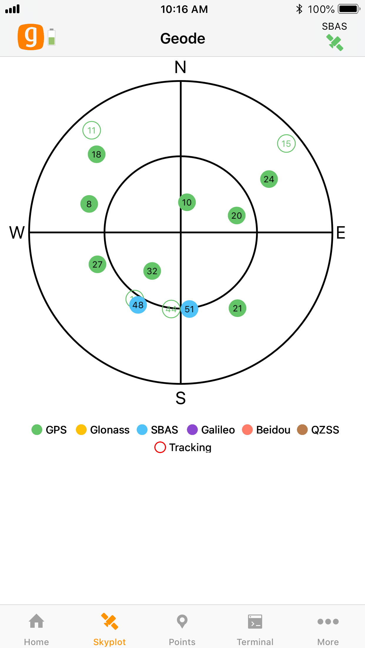
The standard configuration for the Geode is that of a GPS receiver. This means that it receives positioning data from the US government’s GPS constellation of satellites. To calculate an accurate position, the Geode (or any GPS receiver) needs a direct line of sight with at least four satellites. Without that fourth satellite, the receiver has to estimate altitude which can affect horizontal accuracy by hundreds of meters. This is not likely to be a problem if you are collecting data in an open, flat landscape. However, if you are collecting data in the mountains, under heavy canopy, or in a city scape, physical obstructions may make it difficult to view four satellites in the GPS constellation simultaneously.
This is why the Geode also comes with GNSS. GNSS stands for Global Navigation Satellite System, and it encompasses all global satellite constellations from various countries and unions. Specifically, the Geode can receive positioning data from the following satellite constellations: GPS (US), GLONASS (Russia), GALILEO (European Union), BeiDou (China).

With the multi-GNSS configuration, the number of satellites available at any given moment is multiplied. This greatly increases the likelihood that your Geode will be able to get a fix on multiple satellites simultaneously, even under thick canopy or in the middle of a densely populated city block. With more satellites available to the Geode, total data sets in challenging environments are consistently higher quality.
The multi-GNSS configuration of the GNS3 makes the Geode’s ability to deliver precision GNSS more reliable under what used to be considered “less-than-ideal” circumstances.
Note: GNSS accuracy is subject to observation conditions, multipath environment, number of satellites in view, satellite geometry, and ionospheric activity.
GNSS Correction Services
GNSS data (including GPS) will unavoidably have errors in it. Sources of GNSS error include:
- Deviations in GNSS satellite orbits
- Inaccurate clocks on the GNSS satellites
- Ionospheric activity that changes daily and hourly
- Interference of satellite signals that creates noise in the multipath environment
When a manufacturer touts a receiver’s accuracy, it is usually referencing the receiver’s accuracy under ideal conditions. These ideal conditions minimize sources of error. They include flat, open landscapes with clear skies and no buildings or trees interfering with the receiver’s direct line-of-sight to at least four, perfectly positioned satellites. But even these ideal conditions require corrections because the ionosphere is constantly changing and users have no control over satellite orbits or timing.
The Geode is built to be a rugged, go-anywhere GNSS receiver. It is built to perform in all environments, no matter how challenging. This extends even to its receiver capabilities. As with all receivers, it will be more accurate under ideal conditions, but it also has the ability to access and integrate data from various correction and satellite augmentation services, so it provides real-time high accuracy positions in rugged, less-than-ideal environments.
SBAS Differential Correction
The Geode receives Satellite Based Augmentation System (SBAS) data. SBAS includes regional networks of ground and satellite technologies that work together to boost the accuracy and dependability of GNSS/GPS data. SBAS uses stationary land-based GNSS/GPS monitors to calculate GNSS position errors caused by ionospheric disturbances. This error causes delays in timing, which result in position errors.
To calculate GNSS position errors, GNSS data from satellites are compared against the precisely documented locations of each land-based station. Any discrepancy is determined to be an error. These errors are sent to the master control station, which create a real-time regional model for correcting ionospheric errors. This correction model, also known as an ionospheric map, is sent to geostationary satellites and broadcast throughout the region. These SBAS corrections—called deviation corrections—allow GNSS/GPS receivers to more accurately and reliably determine their position.
GNSS is normally accurate to about five meters, but when using SBAS, a user can achieve an accuracy of two meters or better. The Geode combines SBAS corrections with complex smoothing algorithms and full-wave carrier phase tracking to deliver an accuracy better than 60 cm 2DRMS. In other words, 95–98% of the positions recorded by the Geode will be within 60 cm of the true point.
NTRIP and RTK
NTRIP stands for Network Transport of RTCM via Internet Protocol. It delivers the corrections used for Real-Time Kinematic (RTK) Positioning. Where available, RTK and CORS networks stream data corrections over the internet, allowing the Geode to calculate an RTK Fix/Float position solution with differential GNSS accuracy.
NTRIP makes it possible to create networks of localized base stations that increase both availability and precision of RTK corrections. Since distance from a base station strongly affects positioning precision and accuracy, NTRIP-enabled RTK networks are able to calculate the user’s closest base station or use algorithms and modeling to create a virtual base station very close to the user’s receiver. The Geode accesses NTRIP-enabled RTK services via the cellular data or internet capabilities of the device it is connected to. These services require a subscription and a stable internet connection. The Geode uses the data provided by the NTRIP-enabled RTK network to achieve a precise RTK Fix/Float solution.
Atlas Correction Service
The Atlas Correction Service is a worldwide L-band satellite based correction that covers almost all of the land 75° north and south of the equator.
The Geode GNS3M includes an option to subscribe monthly or annually to Atlas to receive extra corrections. The three options provided are Atlas Basic, H30, and H10.
- Atlas Basic—As good as 50 cm accuracy (similar to SBAS) with 95% precision
- H30—As good as 30 cm accuracy with 95% precision
- H10—As good as 10 cm accuracy with 95% precision
This correction service varies depending on tree cover and does not work under a heavy tree canopy.
When using Atlas corrections, the satellites can take time to converge depending on the subscription you have.
- Atlas Basic—Typically 5 minutes or less
- H30—Typically 15–30 minutes or less
- H10—Typically 30 minutes or less
To check the level of subscription of your unit, go to Receiver Configurations > Manage Subscriptions.
When Atlas is enabled, the satellite icon color in the top right corner of Geode connect will indicate the signal quality.
- Blue—Bit Error Rate (BER) between 0 and 20; Excellent signal
- Green—BER between 21 and 150; Good signal
- Orange—BER between 151 and 250; Marginal signal
- Red—BER above 250 to 500; Poor/Unusable signal
These colors can also be seen when using SBAS if the RD1 NMEA sentence is enabled.
Galileo High Accuracy Service (GALHAS)
The Galileo High Accuracy Service (GALHAS) is available on GNS3H models when multi-frequency is enabled. GALHAS is a type of precise point positioning (PPP) correction service that applies orbit, clock, and signal biases to both code and phase portions of the GNSS signals to achieve high-accuracy solutions. In 2025 GALHAS currently provides precise corrections for orbit and clock related errors broadcast through the Galileo Open Service and GPS. The corrections are transmitted in the Galileo E6 signal. In the future the corrections will also include phase biases.
The GALHAS implementation is occurring in phases 0–2. Phase 0 was completed in 2022. Phase 1 was completed on 24 January 2023 with some limitations (such as phase bias corrections) due to the current infrastructure. Phase 2 is underway and includes improved infrastructure, design, and additional data. When completely implemented, GALHAS will have two different service levels. (The current (2025) implementation is a relaxed version of Service Level 1, i.e. without the phase bias corrections.)
|
GALHAS Characteristics |
||
|---|---|---|
| Service Level 1 (SL1) | Service Level 2 (SL2) | |
|
Service Area/Coverage |
Global coverage | Regional coverage for the European Coverage Area (ECA) |
|
Types of Corrections |
Orbit, clock, biases (code and phase) |
Orbit, clock, biases (code and phase) Atmospheric corrections |
|
Delivery Channels |
HAS Signal-In-Space (SIS) HAS Internet Data Distribution Interface (IDD) |
|
|
Accuracy target (95%) |
20 cm horizontal 40 cm vertical |
|
|
Availability target |
99% | |
|
Convergence time target |
300 seconds | 100 seconds |
|
Format |
Open format similar to Compact-CSSR | |
|
Dissemination |
Galileo E6B using 448 bits per satellite per second/terrestrial (internet) | |
|
Constellations |
Galileo and GPS | |
|
Corrected Frequencies |
Galileo E1/E5a/E5b/E6/E5 AltBOC GPS L1/L5/L2C |
|
Update Interval Rate
The standard Geode configuration comes with an update interval rate of 1 Hz. This means the Geode updates its position and outputs that data to the connected device once per second.
An optional upgrade for update intervals up to 10 Hz or 20 Hz (10 or 20 updates per second) is available. These upgrades also allow for update adjustments of 2 Hz, 5 Hz, and 10 Hz. Higher update rates are important for projects in which you are collecting data at faster speeds.
Note: At higher data rates, we recommend turning off messages not required for your application, such as GNS, RRE, and VTG messages.
For more information about how to upgrade the update interval rate, see:
Operating Systems
The Geode GNSS Receiver is able to communicate with a wide range of computing devices such as laptops, tablets, and smart phones. These devices may also run a variety of operating systems, including iPhone, iPad, Android, and Windows 10/11.
Geode Connect
Geode Connect is a simple utility app designed to make the Geode easy to use. Geode Connect provides you with the ability to easily establish a Bluetooth wireless, USB, or serial connection with their handheld device, report position information of the Geode, and customize the most commonly used configuration settings. Although Geode Connect has limited data-capture features, it is not intended to replace your mapping, navigational, or data-collection app. Juniper Systems offers a full mapping software application called Uinta that can be used with the Geode. Juniper Systems also partners with several software developers who offer mapping applications that can be used with the Geode.
Geode Connect is free for download from the Juniper Systems website and various app stores. For more information about downloading and using Geode Connect with your specific operating system, refer to:
- Set Up Geode Connect for iPad and iPhone
- Set Up Geode Connect for Android
- Set Up Geode Connect for Windows PC
Third-Party Applications
The Geode streams NMEA 0183, RTCM, and Crescent Raw Binary data protocols, which makes it compatible with most mapping, navigational, and data-collection software. It will usually work seamlessly with the app that you are already using. It will simply improve the precision, accuracy, and reliability of your data. For a list of professional GPS and GNSS data-collection apps, visit the Juniper Systems blog at blog.junipersys.com and search for data-collection software.
Note: When using the Geode with Android devices, some mapping and data-collection apps do not readily indicate which receiver they are connected to, the highly accurate and reliable Geode GNSS Receiver or the device’s own internal, consumer-grade GPS receiver. For information about identifying and solving this problem, see Connect Device.
Juniper Rugged™
Like other Juniper Systems products, the Geode is built ultra-rugged—waterproof, dustproof, and drop proof. It is designed to withstand harsh environments. It features IP68-rated protection, meets or exceeds MIL-STD 810G (drop, vibration, temperature, ingress protection), and operates in extreme temperatures, providing reliable performance wherever you need to collect data.
Bluetooth® Wireless Technology
The Geode is equipped with a Class 1 Long Range Bluetooth wireless transmitter. It has a range of approximately 100 meters or 328 feet. However, the device you are pairing with the Geode may or may not have the same range. It may be a good idea to test this range before relying on it heavily. For instructions on pairing your Geode with your handheld device or laptop, see Getting Started.
Antennas
Juniper Systems offers two GNS3 models, the GNS3M and the GNS3S.
- GNS3M—Includes a multi-frequency antenna (L1, L2, L5) and an option to subscribe to receive Atlas corrections.
- GNS3S—Includes a single frequency antenna (L1). This configuration cannot be updated to a GNS3M multi-frequency.
For applications involving dense canopy or other skyline interference, the Geode includes an external antenna port allowing you to place an external antenna in an area with better sky visibility. Consult Juniper Systems Technical Support before using the Geode with an external antenna.
LED Status Indicators
There are four LED Status Indicators on the face of the Geode.
 |
Amber LED: Blinks when a 3D GPS fix is made (four or more satellites) and turns solid when a DGPS fix is made (a correction source is being applied to the solution). |
 |
Blue LED: Solid when the Geode unit is connected via Bluetooth wireless technology in Geode Connect. |
 |
Red LED: 1) Blinks slowly when battery is charging. 2) Solid when battery is fully charged. 3) Blinks rapidly when battery cannot accept a charge (for example, from a laptop computer that doesn’t have enough power to charge the Geode or other faulty power supply). |
 |
Green LED: 1) Solid when the power is turned on. 2) Blinks when the battery needs to be charged. |
Power Supply and Battery
The Geode uses a 15 W, 100–240 V AC universal USB power supply with wall charger for charging the internal battery. Power adapters for the US, UK, EU, and AU/NZ are available from Juniper Systems.
The following USB cables work for charging the battery:
- USB-C to USB-C—Recommended for use as a primary charging cable. Use this when the device is powered on and charging at the same time. This cable can also be used for data transfer.
- USB-A to USB-C—Legacy cable used for charging when the receiver is powered off.
The Geode has an internal, non-removable battery that can provide 10+ hours (up to 16 hours for the GNS3S) of use. The battery may require as much as six hours to charge before the first use. Subsequent charges should take four hours or less, depending on the remaining power.
When not in daily use, charge the Geode periodically to 50% power. Do not allow the battery to become completely depleted as it may not recover.
If you do not plan to use the Geode for more than a month, charge/discharge the battery to about 50% (the optimal charge level for storage).
To charge the Geode in the field, use the included USB cable and a vehicle USB adapter to plug the Geode into a vehicle’s 12 V power port. For best results, use an adapter that is rated at least 10 W/2.1 A.
Charging the Geode by connecting it to a battery-powered PC or handheld device is not recommended. Most of these devices do not have enough power to charge the Geode. If the Geode detects it is connected to a battery with insufficient power, it will not charge. The red light will flash rapidly indicating that the Geode is not charging. If you connect the Geode to a device via USB for data transfer, the red light may still flash rapidly to let you know that the battery isn’t charging. This does not affect the data transfer.
![]() CAUTION: The Geode needs to be charged periodically. If the battery drains completely, it may not recover, and your Geode will need to be sent to Juniper Systems for a battery replacement.
CAUTION: The Geode needs to be charged periodically. If the battery drains completely, it may not recover, and your Geode will need to be sent to Juniper Systems for a battery replacement.
Connector Ports
The Geode comes standard with a USB-C port for charging the receiver and for connecting it to a PC or handheld device. It also comes with an external antenna port. This port will supply the external antenna with 3.3 V at up to 45 mA of power. Consult Juniper Systems Technical Support before using the Geode with an external antenna.
The Geode includes a Serial RS-232C 9-pin port. This allows the Geode to be mounted to a piece of equipment while maintaining a constant connection for data and power. Use a straight-through 9-pin cable to communicate with your Geode. For a list of functions for each pin, refer to Appendix A: Serial Port Configuration.
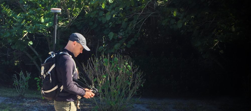
Carrying Options
The Geode can be carried in a number of different ways. It can easily be carried in-hand, in a pack, or mounted on a pole, depending on what your individual needs are.
For a complete list of carrying options, visit the Geode page on the Juniper Systems website or go to the blog at blog.junipersys.com and search for Geode.
Camera Tripod Mount
The Geode can be attached to a camera tripod using the 1/4 in.–20 mounting hole in the case. The screw must be less than 7 mm (0.3 in.) long to avoid damaging the case. Also included with the Geode is a 5/8 in.–11 adapter that fits into a camera tripod hole. This will allow the Geode to be mounted to a standard 2 m survey pole.
Mounting Plate
The Geode can be mounted diagonally on a standard AMPS-style mounting plate. Many other attachments support the AMPS diagonal style mounting interface. Use attachment screws size M4 (less than 4.5 mm (0.17 in.)).